
Miles on trip: 4104 miles
Countries: 8
Days on trip: 35
Number of ferries taken in Norway: 10
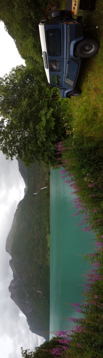
After having spent a fair amount of time at the fjords it was time to make some distance up north. After all we don’t want to spend the entire year in Norway (although there would be plenty to see). We could take the quick route up north – via the E6, but then again we weren’t in that much of a rush either and we wanted to see the landscape rather than take the quickest way up.
Our first road along the coast was the Atlanterhavsvegen. To get there we had to get two ferries. They were both short and ran frequently. So it was just a matter of turning up and waiting a couple of minutes. Eventually we made it to Bud, the start of the Atlanterhavsvegen tourist route, and then drove up along the coast enjoying the Atlantic on our left. The scenery was completely different to the fjords. You felt like you were close to the ocean (okay, not a surprise) and everything was pretty flat. There were a lot of rocky islands or peninsulars and one of them had a pretty impressive bridge going over it. You drove 30m over the Atlantic with a view of mainly water (and a bit of land) on both sides.


We stayed in Kristiansund (at a camp site) over night and then drove further up north the next day. For the next few hundred miles there wouldn’t be any tourist routes but we kept driving along the coast towards Trondheim. Near Trondheim is a town called Hell. There isn’t much about Hell, except for the name but since it was only a detour of 10km, we figured it was worth a visit and since we needed somewhere to stay the night we thought why not find something in or near Hell. This is where we found our best wild camping spot so far. We found somewhere in the woods, away from the road, right next to a lake and a little stream. The spot also had a little bench and people had previously been there and had a camp fire. So after our dinner (bbq’ed salmon) we decided to collect some wood and get the fire going. With the heat from the fire, the beautiful view and a nice glass of wine this was definitely not hell.


To get to the start of our next tourist route, Helgelandskysten, we had to go a bit further north and take another ferry. We have now officially entered Northern Norway. Helgelandskysten is the longest of the tourist routes with 433km and has 5 ferries along the route. It jumps to different islands and peninsulars past farmed country side, rocky islands and beautiful ocean views. It also crosses the arctic circle (on a ferry). Martin was especially excited about that since he had been asking Andi for several hours whether we had already crossed it.


We stayed mainly on the tourist route but there are a lot of people who come here to cycle and hop to the different islands. Andi could definitely see that charm in it, especially when she found out that one of the islands has puffins.
Our next stop would be Lofoten and we had several options of getting there. From Bodo there are ferries to Moskenes, in the south of Lofoten. The ferry ride is supposed to be a little rough and takes 3-4 hours. It is recommended that you book in advance because otherwise you will have to wait for several hours at the port. Another option is to drive all the way north and then south down the Lofoten. However, since that’s quite a bit of driving, fuel money and time (we wanted to make it north to catch the end of the midnight sun) we decided on the ferry.
However, the fast 3-4 hours ferries were all fully booked when we went online the day before. So it was either drive all the way to Lofoten, spend a night in Bodo to take a booked ferry the following day, wait in Bodo and get a ferry at midnight or book a 7.5h very via Rost and Vaeroy (two islands). We decided to go for the long ferry. So at 8.30pm the day before we started booking that ferry. Bookings had to be done by 9pm. Plenty of time, except everything was in Norwegian and we had to google translate it all so that we’d book the right thing. (Of course we translated and read all the T&Cs.) Flipping back and forth between google translate and the website we were finally ready to press the last button at 8.55pm. Right then our roaming decided to give up and we had no more 3G. Luckily it came back a few min later and we didn’t have to resubmit the form. All good.
The next day we had one more short ferry to get to Bodo and then the big 7.5h one. The ferry to Moskenes wasn’t the most luxurious one but we played on our phones, watched an episode of Top Gear and did some route planning. When stopping at Rost and Vaeroy we were planning on taking some photos of the islands but visibility was pretty bad so that you could barely see what was in front of you. Luckily as we entered Lofoten the view got a bit better and it was a spectacular way to arrive in Moskenes. Nice rocky islands and the layers of cloud gave the place some sense of mystery.

The next day we explored the Lofoten. We started in A, the village furthest south and then drove up north via a few detours. The scenery was stunning with amazing views. Driving through different parts the weather kept changing. In some areas there was terrible visibility and then a couple of minutes later it was nice and sunny, blue sky. There were also some lovely, white, sandy beaches. With the sunny weather they looked very inviting so we dipped our feet in. Okay, water temperatures aren’t quite those as in southern countries but at least we can say we were in the arctic water. (Others were braver and went in completely.)


One of the detours we did in the Lofoten was to Henningsvaer, also named the Venice of the Lofoten. There were a few bridges (of course) and more lovely views and since it was close to the end of the day and the sun was shining we splashed out and enjoyed a Ben and Jerry’s cookie dough ice cream. Life is good.
This was also the last stop in the Lofoten. From here on our journey would take us further inland.


")
")
")
")

")
")


